Just Wing It – Aerial Surveying for Pipeline Projects (Source: Civil + Structural Engineer)
By Hunter Hanson
Quality site survey data is an integral component of all pipeline design projects, which can become quite costly and time consuming as the scale of the project increases. For Alliance Regional Water Authority’s (ARWA) Phase 1B Program, which includes 95 miles of water transmission lines serving several communities in central Texas, aerial surveying helped achieve cost savings and reduce schedule risk.
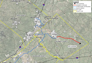
Lockwood, Andrews & Newnam, Inc. (LAN), partnering with Dallas Aerial Surveys (DAS), performed a fixed-wing aerial survey in conjunction with traditional surveying methods on one of the program’s pipeline segments to optimize efficiency. The pipeline segment, called Segment A, involved 17 miles of 48-inch water line and began at the proposed water treatment plant in eastern Caldwell County and terminated just south of the City of Lockhart (See Figure 1).
Project Approach
From the conception of the Segment A project, there were multiple challenges with the surveying component. The long, linear pipeline segment is in a rural area and traverses heavily wooded areas. This location, coupled with the rolling hill terrain of central Texas, lead the design team to pursue an aerial survey to collect the design data needed. However, the frequent changes in topography and thick vegetation triggered concerns that pockets of topography data could be obscured, potentially leaving out an important level of detail needed to design the pipeline. Therefore, an approach utilizing an aerial survey in tandem with limited ground survey was crafted to optimize the surveying process without compromising data quality.
A fixed-wing aircraft was selected to perform photogrammetric and LiDAR flights. The surveying data specifications are listed below:
CLICK HERE TO READ COMPLETE STORY

